Dimdima
Online Children's Magazine from India
Dimdima
Online Children's Magazine from India


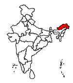
Area : 83, 743 sq.km. The largest state in the north-east.
Population : 10,96,702. Tribals constitute seventy nine per cent of the population (Mongoloid and Tibeto-Burmese in origin).
Languages : Tribal dialects—Hill Miri, Monpa, Nishi, Sherdukpen, Mishmi, Apatani, Wancho, Dafla, Khamti.
Capital : Itanagar in the foothills of the Himalayas. It has been identified as Mayapur, the 14th century historic city of the Jitri dynasty.
Towns :
Bomdila at a height of 2,530 metres has apple orchards and Buddhist monasteries, the Gompas.
Dirang has apple orchards, sheep-breeding farms and the Kalachakra Gompa.
Tawang is a place of Buddhist pilgrimage and a trout-farming centre.
Geography :
Stretching from the snow-capped eastern Himalayas, at an altitude of 6,000 metres, to the plains of the Brahmaputra valley, Arunachal Pradesh lies at the country's north-eastern tip, surrounded by Bhutan, China and Burma. Assam lies to its south.
Rivers :
Kameng, Subansiri, Siang (later Brahmaputra in Assam), Lohit and Tirap.
Climate :
Varies according to altitude.
Upper regions : Winters are cold and humid. Summers are short.
Rainfall :
400 cm annually. Forests cover two-thirds of the state and are abundant in orchid species some of which are among the world's rarest.
LOOKING BACK :
IN 1826 the British annexed Assam and extended British influence into the northeast region of India. By 1912 the region now called Arunachal Pradesh was being administered from Assam.
In 1954 the area became known as the Northeast Frontier Agency.
Arunachal Pradesh became a Union Territory in 1972 and then, a full-fledged state in February 1987.
SIGHTS AND SOUNDS:
Arunachal Pradesh is one of our greenest states with a large part of it covered with forests. You'll see only forest-based businesses here — like timber yards and saw mills, no large manufacturing industry.
Nearly 80 per cent of the population is engaged in agriculture. The main crop is rice. Maize, millet and pulses are some of the other crops grown in Arunachal Pradesh.
You could walk miles without seeing anyone. Population density is the lowest in Arunachal Pradesh with only about 10 people per square kilometre. (In comparison, Haryana has a population density of 369; Punjab 401; Bihar 497).
As Arunachal Pradesh is a strategically important border state — with Bhutan, China and Myanmar as neighbours — foreign tourists have restricted access. However the government is trying to promote eco-friendly tourism in some parts of the state.
PLACES TO VISIT :
The 400-year-old Tawang Gompa, India's largest Buddhist monastery.
Namdapha National Park.
The holy Parasuram Kund, a lake near Tezu in Lohit district. A place of pilgrimage for Hindus who bathe here on Makar Sankanti.
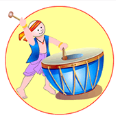
Dimdima is the Sanskrit word for ‘drumbeat’. In olden days, victory in battle was heralded by the beat of drums or any important news to be conveyed to the people used to be accompanied with drumbeats.
Bharatiya Vidya Bhavan
K. M Munshi Marg,
Chowpatty, Mumbai - 400 007
email : editor@dimdima.com
Bharatiya Vidya Bhavan
505, Sane Guruji Marg,
Tardeo, Mumbai - 400 034
email : promo@dimdima.com
Dimdima.com, the Children's Website of Bharatiya Vidya Bhavan launched in 2000 and came out with a Printed version of Dimdima Magazine in 2004. At present the Printed Version have more than 35,000 subscribers from India and Abroad.