Dimdima
Online Children's Magazine from India
Dimdima
Online Children's Magazine from India


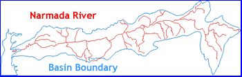
The Narmada river is central India’s most important waterway. The 1312-km-long perennial river flows through Madhya Pradesh, Maharashtra and Gujarat, before emptying into the Gulf of Khambat near Bharuch. The first 1,077 km of the river flows in Madhya Pradesh and over the next 35 km, it forms the boundary between Madhya Pradesh and Maharashtra. Again for the next 39 km, it forms the boundary between Maharashtra and Gujarat. The last stretch of 161 km lies in Gujarat. Out of the total catchment area of about 1 lakh sq. km 87% lies in Madhya Pradesh, 2% in Maharashtra and 11% in Gujarat. It is India’s fifth-largest river and the larger of the two Indian rivers that flow from east to west, the other being the Tapti. The Narmada is also regarded as the dividing line between North and South India, as it flows through the valley formed by the Vindhyas to the north and Satpura ranges to the south.
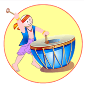
Dimdima is the Sanskrit word for ‘drumbeat’. In olden days, victory in battle was heralded by the beat of drums or any important news to be conveyed to the people used to be accompanied with drumbeats.
Bharatiya Vidya Bhavan
K. M Munshi Marg,
Chowpatty, Mumbai - 400 007
email : editor@dimdima.com
Bharatiya Vidya Bhavan
505, Sane Guruji Marg,
Tardeo, Mumbai - 400 034
email : promo@dimdima.com
Dimdima.com, the Children's Website of Bharatiya Vidya Bhavan launched in 2000 and came out with a Printed version of Dimdima Magazine in 2004. At present the Printed Version have more than 35,000 subscribers from India and Abroad.