Dimdima
Online Children's Magazine from India

Dimdima
Online Children's Magazine from India
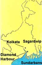
From Kolkata we proceed to Achighat (Achipur) where the first Chinese settlement was established in the 1840's. Achighat is better known as China Town.
Just before the Hooghly or the Ganga turns south to join the Bay of Bengal, it broadens to form an estuary at the Diamond Harbour. Once, the ships of the East India Company anchored here; now it is mostly used by motor launches and country boats to ferry passengers around the estuary.
South of the harbour lies the world's largest delta, formed by the innumerable mouths of the Ganga together with those of the Brahmaputra further east. As a result of the enormous amount of silt brought in by these mighty rivers, new lands and islands, especially on the eastern seaward side of the delta, form at a rapid rate. At the same time a great deal of land is also swallowed by the sea.
The delta region has a vast tract of tidal forests and swamplands that stretch halfway from Kolkata to the Bay of Bengal and into Bangladesh in the east. They cover an area of 15,500 sq km-and are among the world's largest mangrove forests.
The forests are called the Sundarbans meaning beautiful forests or the forests of the Sundari trees. The Sundarbans is the oxygen forming belt of Kolkata - the lungs of the city! They are also a natural barrier. But for these mangrove forests, the tidal waves would have devoured Kolkata and most of the surrounding land.
Millions and millions of bioluminescent microorganisms glow at night during winter transforming the mangrove's surface into a fairyland. Boats weave their way through tall spikes which are roots that stick out of the muddy ground to absorb air. The sundari, goran, gerwa, dhundal and the kewa grass thrive in the salty marsh.
Few areas in the world have such diversity in animal species. Royal Bengal tigers live in the midst of ferocious
crocodiles, sharks, lizards (including the rare Salvator lizard), birds, porpoises, fish, turtles, snakes, honey bees, crabs, snails and innumerable vertebrate and invertebrate species.
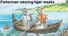 The mangrove contains about 300 to 500 tigers - the largest single surviving population of tigers in the world. They lead a semi-aquatic life and can swim long distances. The inhabitants of the Sundarbans, mostly honey collectors and fishermen accept a tiger attack as a professional hazard. Some of them wear masks painted with human faces on the back of their heads as a tiger is less likely to attack if it thinks that it can be seen. And before venturing into the forests, they invoke the blessings of Dakshini Rai, the tiger god and principal deity of the forest.
Destruction of the forest was rampant before the government declared it a protected area. The Haliday, Sajnakhali and Lothian islands were made into wildlife sanctuaries. In 1972, Project Tiger was launched. The hunting of tigers was abolished and measures were taken to save their vanishing home. The mangrove forests were formed into a National Park and a Tiger Reserve in 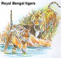 1984. The Sundarbans is the world's first mangrove forest that was brought under scientific management and is listed as a World Heritage site.
Sagardwip, at the mouth of the Ganga, is the largest of the 102 islands of the Sundarbans. It was almost completely reclaimed from mangrove swamps. It used to be one of poet Rabindranath Tagore's favourite haunts. He is said to have written many of his letters and lyrical poems while on this island.
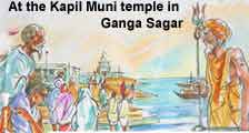 The island's southernmost tip is known as Ganga Sagar. Millions of Hindu pilgrims gather here on Makar Sankranti (January 14) for a holy dip in the Ganga before having darshan at the celebrated temple of Kapil Muni. A three-day mela is held here.
The island has one of the oldest functioning lighthouses that was set up in 1821.The lighthouse stands twenty-six metres above sea-level. Its light is visible up to a distance of 16km in clear weather.
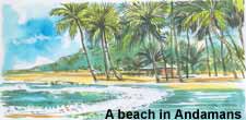 A thousand kilometres from Kolkata, in the Bay of Bengal, lies Port Blair, the capital of the Andaman and Nicobar islands. The islands of Andaman and Nicobar run parallel to the country's east coast. They form an arch-shaped, narrow, broken chain of islands that spread 780km along the Bay. The northernmost island, the
  Landfall island is about 190km from Myanmar while the southernmost island, the Great Nicobar, is barely 150km from Indonesia.
The name Andaman is said to have derived from Hanuman, pronounced Handuman by the Malays, who had known these islands from time immemorial. Handuman became Andaman over the years.
The Nicobar islands were called Nakkavaram, the land of the naked since ancient times, probably because the tribals wore no clothes. The Portuguese who came to the islands in the 15th century called it Nacubar and later Nicobar.
During British rule, a penal settlement was established in North Andamans. Thousands of sepoys who took part in the Great Revolt of 1857, and other political prisoners were sent out there to die. The islands were looked upon with dread and called Kalapani or black water as it was believed that they contained black, brackish drinking water and little vegetation.
This myth was disproved soon after India became independent, and in less than a decade thereafter, the islands of Andaman and Nicobar were constituted into a Union Territory, on November 1, 1956.
Last updated on :5/28/2021
Dimdima is the Sanskrit word for ‘drumbeat’. In olden days, victory in battle was heralded by the beat of drums or any important news to be conveyed to the people used to be accompanied with drumbeats.
Bharatiya Vidya Bhavan
K. M Munshi Marg,
Chowpatty, Mumbai - 400 007
email : editor@dimdima.com
Bharatiya Vidya Bhavan
505, Sane Guruji Marg,
Tardeo, Mumbai - 400 034
email : promo@dimdima.com
Dimdima.com, the Children's Website of Bharatiya Vidya Bhavan launched in 2000 and came out with a Printed version of Dimdima Magazine in 2004. At present the Printed Version have more than 35,000 subscribers from India and Abroad.